
Landing Zone Oasis
Staff Sergeant Arlen Tuttle was an engineer with the 8th Engineer Battalion, 1st Cavalry Division, and he was killed on 5 November 1965. Days later his division fought the Battle of the Ia Drang. The patch of red ground the cavalry had cleared southwest of Pleiku to support that fight was given his name — LZ Tuttle — and for a while that is what it was called. Then the name changed to something a pilot could find on a map and a soldier could say without thinking about anybody. LZ Oasis outlived Tuttle's name by six years.
Twenty-Four Kilometres Down Highway 19
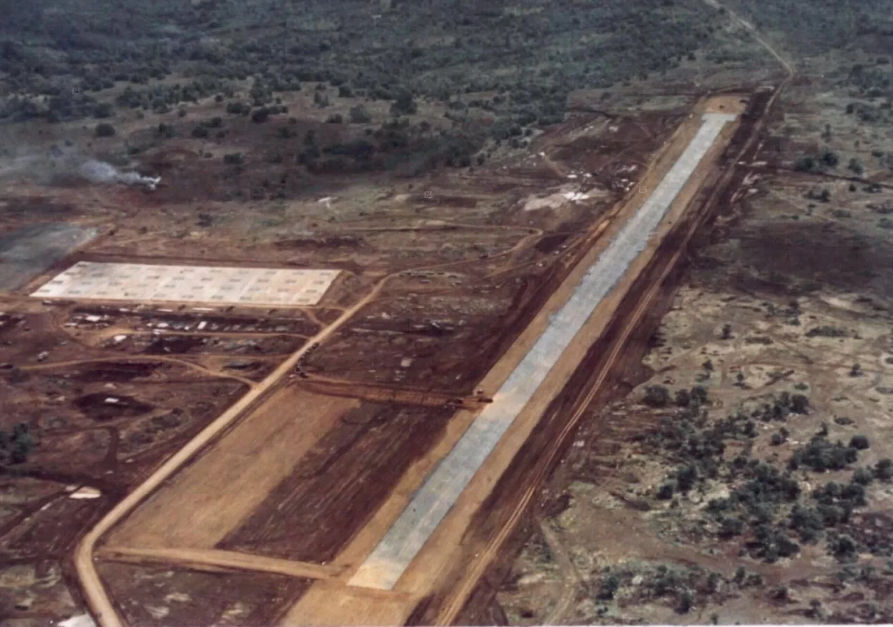
The base sat just south of QL-19, the road that climbs from the coast at Qui Nhơn through the An Khê and Mang Yang passes to Pleiku and then runs west to Cambodia. Oasis was twenty-four kilometres southwest of the city, out where the plateau opens up and the highway stops feeling like a lifeline and starts feeling like a target. The strip they laid there was 3,500 feet of laterite at 1,770 feet of elevation — no matting, no concrete, just the packed red tropical soil that gives the Central Highlands their colour and, in the dry season, coats everything within a hundred metres of a landing helicopter. An aerial photograph taken in April 1967 shows the whole installation in one frame — a cleared patch on an otherwise empty plateau, which is exactly what it was.
Built for the Ia Drang
It was thrown up in 1965 because the 1st Cavalry Division needed somewhere forward to work from. The Ia Drang campaign that November was the first sustained collision between American and North Vietnamese regular forces, fought in the valley and on the slopes of the Chu Pong Massif west of here, and Oasis was one of the places the helicopters came back to. What the base was for never really changed after that. Everything west of it — the border, Chu Pong, the Ia Drang, the infiltration corridors — was the reason the base existed, and everything the base did was a version of going out there and coming back.
Task Force Walker
The 25th Infantry Division reopened Oasis in May 1966 with Task Force Walker, and the brigade flew straight out of it into Operation Paul Revere, sweeping southwest, then west toward the massif, for the next eleven weeks. Oasis was the fixed point that operation kept returning to: when interrogators finally located the PAVN 32nd Regiment at the end of July, it was described by its distance from here — ten kilometres southwest — and the last battle of the operation was fought at a landing zone seven kilometres out in the same direction. Later the 3rd Brigade, 4th Infantry Division took the base over. Over the years the tenant list grew long and heavy: the 1st Squadron, 10th Cavalry; the 69th Armor from September 1968 into 1970; the 165th Aviation Group; the 5th Battalion, 22nd Artillery with its eight-inch and 175mm self-propelled guns in 1968; the 7th Battalion, 15th Artillery through 1971.
In the Wire
On 11 May 1969 an estimated six hundred North Vietnamese soldiers attacked Oasis. Eleven Americans were killed, three were taken prisoner, and roughly a hundred of the attackers died — the sort of arithmetic that gets written down as a successful defence and lived through as something else. Eighteen months later, on 30 October 1970, they came again. This time the base was held by the 6th Battalion, 14th Artillery with elements of B Battery, 4th Battalion, 60th Artillery, and the attack cost three American dead and twenty wounded. Artillerymen defending their own guns is what a firebase is; the interval between those two nights is what most of the six years actually felt like.
The Guns Go Home
The 7th Battalion, 15th Artillery was still firing from Oasis in October 1971, and by the end of that year the Americans were gone from it. Nothing dramatic marked the closure — the guns were lifted out, the strip was left to the weather, and the war in the Highlands went on without an American base twenty-four kilometres southwest of Pleiku. The laterite has long since gone back to farmland and scrub. The map point remains, though, and it is worth knowing why the place existed at all: because in the autumn of 1965 an army needed a cleared patch of dirt west of Pleiku, and because an engineer named Arlen Tuttle did not come home from making it.
From the Air
Landing Zone Oasis stood at 13.805°N 107.872°E, about 24 km southwest of Pleiku and just south of QL-19, at 1,770 ft elevation. Its 3,500 ft laterite strip is long gone; from the air, look for the highway running west-southwest out of Pleiku across open red-earth plateau, with forested ridges rising toward the Cambodian border and the Chu Pong high ground beyond. Best viewed at 2,500-4,000 ft AGL, low enough to pick out field boundaries on the old perimeter. Nearest airport is Pleiku (VVPK), roughly 24 km northeast; the Ia Drang valley lies southwest. Dry-season mornings (December to March) give the cleanest air; from May onward expect afternoon convection and reduced visibility in monsoon rain.
Nearby Stories
- Yali Falls Dam 20 km away
- Lake Yeak Laom 24 km away
- Kon Ka Kinh National Park 32 km away
- Virachey National Park 38 km away
- Camp Radcliff 45 km away
- Buôn Đôn 70 km away
- Chư Yang Sin National Park 75 km away
- Sen Monorom 121 km away